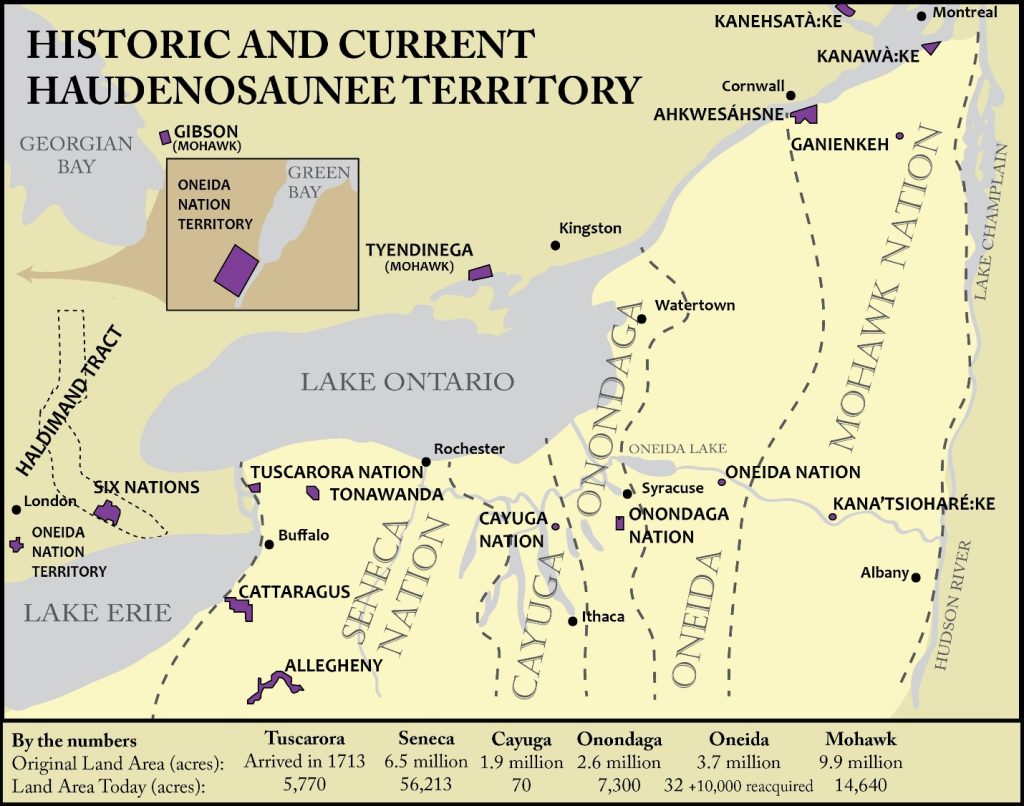
Haudenosaunee territory
Historic maps are often inaccurate. Map makers at times reinforced the political objectives of the colonizers. The Haudenosaunee did not draw lines on the ground to mark their territory. Modern maps, like this one, try to be more accurate, but the boundary lines should be more like buffer zones rather than definitive boundaries.
“Reservation” boundaries fluctuated through time, as with the Haldimand Tract, originally seen as the dotted line on the left and the remaining “reserve” as the purple figure within the dotted line. However, this map does show the extent of the land dispossession suffered.
- – Tuscarora Nation, near Lewiston, NY
- – Tonawanda Seneca Nation, near Akron, NY – https://alliesoftsn.weebly.com/about-the-tonawanda-seneca-nation.html
- – Cattaraugus Seneca Territory, near Irving, NY – https://sni.org/
- – Allegany Seneca Territory, Salamanca, NY – https://sni.org/
- – Onondaga Nation, near Syracuse, NY – https://www.onondaganation.org/
- – Oneida Nation, near Verona, NY – https://www.oneidaindiannation.com/
- – Cayuga Nation, near Gowanda, NY – History & Culture – Haudenosaunee Traditions | Cayuga Nation
- – Akwesasne, near Massena, NY. – http://www.akwesasne.ca/ and https://www.srmt-nsn.gov/
- – Ganienkeh Territory, near Altoona, NY – http://www.ganienkeh.net/
- – Oneida Nation, near Green Bay, WS – https://oneida-nsn.gov/
- – Seneca-Cayuga Tribe, in Oklahoma – https://sctribe.com/
- – Kahnawà:ke, near Montreal, Quebec – https://kahnawake.com/
- – Kanehsatà:ke, near Lake of Two Mountains or Oka, Quebec – https://www.kanesatake.ca/wp/
- – Six Nations of the Grand River Territory, near Brantford, ON – https://www.haudenosauneeconfederacy.com/ and https://www.sixnations.ca/
- – Tyendinaga Mohawk Territory (Bay of Quinte), near Shannonville, ON – https://mbq-tmt.org/
- – Oneida Nation of the Thames, near London, ON – https://oneida.on.ca/
- – Wahta Mohawk Territory (Gibson), near Bajla, ON. – https://www.wahta.ca/
- – Mohawks of the Michel’s Band near Jasper, Alberta, Canada. (They gave up their status as Indians in 1958 and are being re-established as the Michel Callihoo Nation Society. Callihoo (Louis Kwarakwante from Kahnawà:ke) was one of the voyageurs who moved to the area; his son Michel Callihoo signed Treaty 6 in 1878 to establish the band that included Cree and Metis.